Coevolution of climate and volcanic landscapes
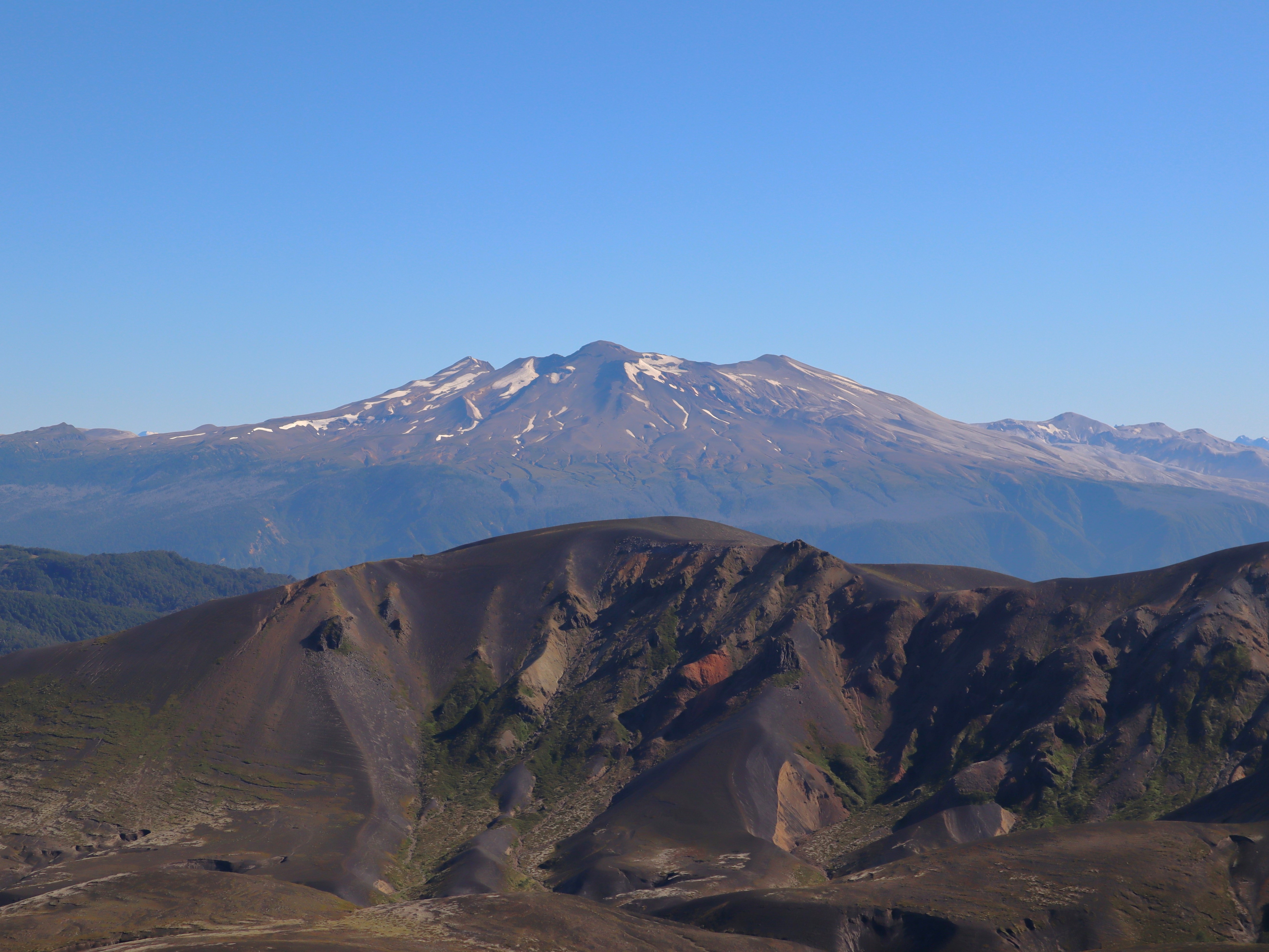
Glaciers are powerful and efficient agents of topographic change, and warming climatic conditions mark a juncture in the way many landscapes are evolving as they re-emerge from beneath retreating glaciers. Active volcanic environments are uniquely impacted by conditions deep within Earth's crust— these conditions control how often, how explosively, and how much mass is erupted. Can surface processes impact crustal conditions that control eruption traits? How do glacial and interglacial cycles play a part? My collaborators and I have taken to the Southern Volcanic Zone in Chile as a natural laboratory to answer these questions.
Approach: Topographic analysis, topographic reconstruction, landscape evolution modeling
Tools: QGIS, Python
Advisors: Ken Ferrier, Mike Cardiff
Collaborators: Brad Singer, Shaun Marcott,
Meredith Townsend, Chris Huber,
Ben Edwards, Josh Cuzzone,
Pablo Moreno-Yaeger, Sally Stevens, Brent Alloway,
Matias Romero
Authored/ Co-authored publications:
• Pablo Moreno-Yaeger, Brad S. Singer, Benjamin R. Edwards, Brian R. Jicha, William O. Nachlas, Mark D. Kurz, Rachel E. Breunig, Ivo Fustos-Toribio, Daniel Vásquez Antipán, Ella Piergrossi, 2024, Pleistocene to recent evolution of Mocho-Choshuenco volcano during growth and retreat of the Patagonian Ice Sheet. GSA Bulletin, DOI: https://doi.org/10.1130/B37514.1t
• Brad S. Singer, Pablo Moreno-Yaeger, Meredith Townsend, Christian Huber, Joshua Cuzzone, Benjamin R. Edwards, Matias Romero, Yasmeen Orellana-Salazar, Shaun A. Marcott, Rachel E. Breunig, Ken L. Ferrier, Kathryn Scholz, Allie N. Coonin, Brent V. Alloway, Marissa M. Tremblay, Sally Stevens, Ivo Fustos-Toribio, Patricio I. Moreno, Franco Vera, Alvaro Amigo, 2024, New perspectives on ice forcing in continental arc magma plumbing systems. Journal of Volcanology and Geothermal Research, DOI: https://doi.org/10.1016/j.jvolgeores.2024.108187
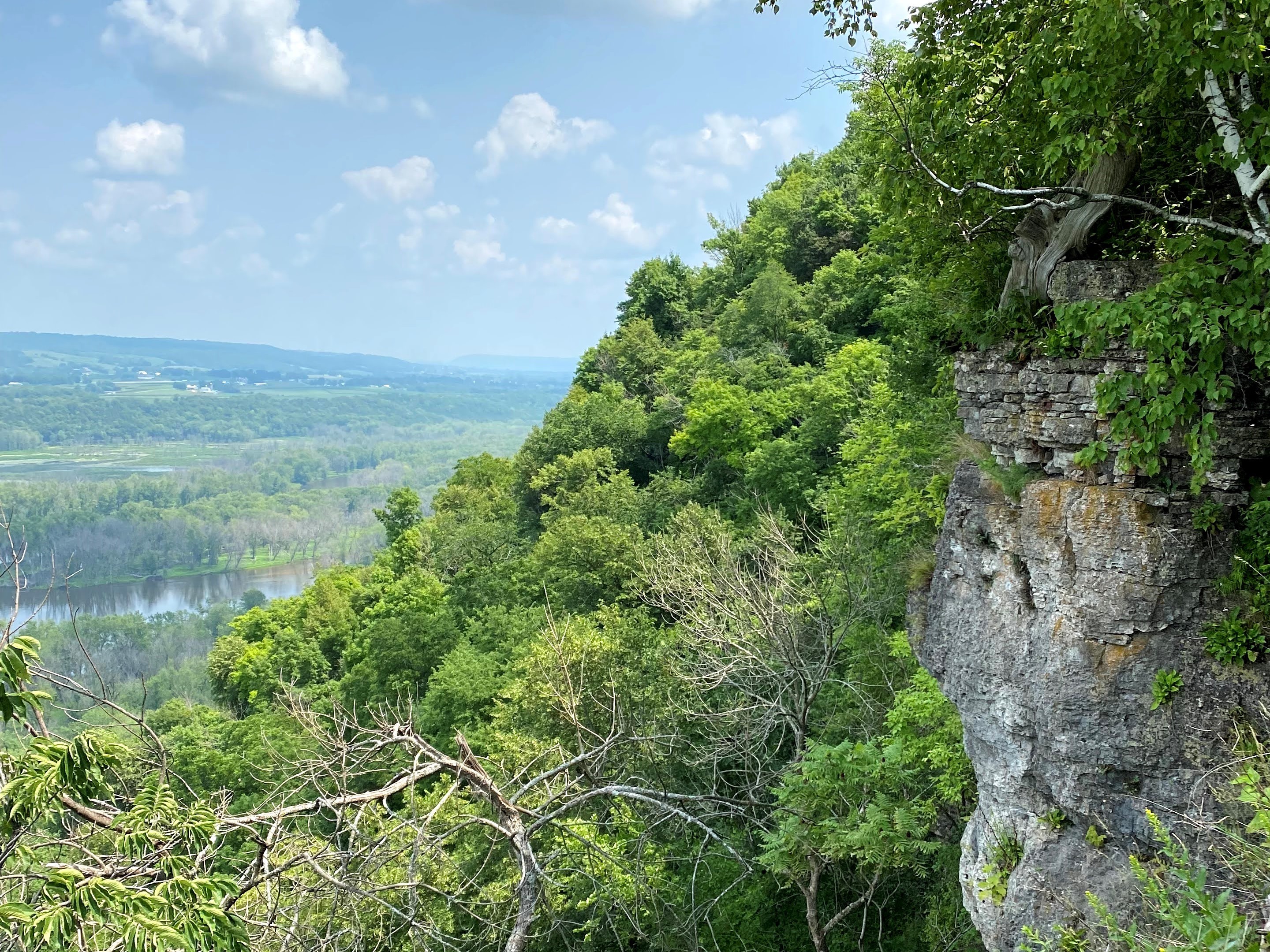
Interactions of Critical Zone structure, evolution, and topography on a hillslope scale
The Critical Zone is Earth’s thin outer layer where life, water, rock, and the atmosphere interact. Water movement through this zone is influenced by both surface and subsurface structures. As water flows through hillslopes, it reacts with minerals in soil and rock, altering their chemistry and structure through a process called weathering. In the Driftless Area—home to Wyalusing State Park—the landscape consists of deeply dissected layers of carbonate and silicate rocks, partially covered by windblown silt known as loess. I use this landscape to explore how hillslope shape influences weathering patterns, how variations in primary rock regulate weathering and stream chemistry, and how dust contributes to the evolution of the Critical Zone.
Approach: Direct-push coring, field observations, core logging, laboratory analysis for physical and chemical characterization of cores, laboratory aqueous chemical analyses, topographic analysis
Tools: GeoProbe MacroCore 5 (MC-5) coring system, Environmental Subsoil Profiler Plus (ESP+), mass-balance derived weathering indices, Spex Shatterbox, Spex 3636 Xpress, Bruker Tracer III-SD XRF, Agilent 5110 ICP-OES, Matlab, QGIS, Topotoolbox, Adobe Photoshop, Adobe Illustrator
Advisors: Ken Ferrier, Mike Cardiff
Collaborators: Eric Carson, Kai Hu, Hannah Justice (undergraduate mentee), Valerie Bares (undergraduate mentee)
Weathering, porosity production, and water storage in first order hillslopes
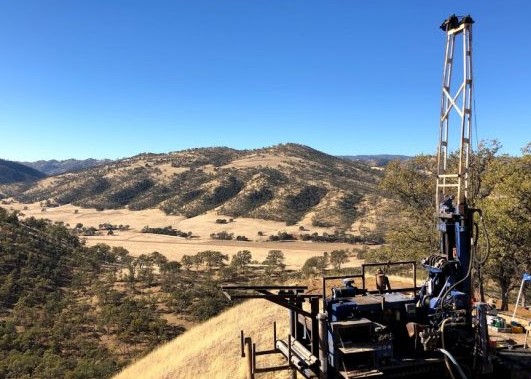
Where does water reside in first-order hillslopes, and how was the storage capacity that accomodates that water generated? During my undergraduate research at the Jackson School of Geosciences, I worked on projects addressing these questions. My undergraduate thesis focused on developing a new approach to mass-balance derived weathering indices that account for bedrock heterogeneities in sedimentary rock. I also worked with a team to physically and chemically characterize cores of rock that traversed the Critical Zone at Rancho Venada and Antelope Valley Ranch (Eel River Critical Zone Observatory, Northern California) and further interpret the controls of chemical erosion, topography, and climate on the distribution of water in the subsurface.
Approach: Field observations, core logging, laboratory analysis for physical and chemical characterization of cores, topographic analysis
Tools: Micromeritics AccuPyc II 340 Gas Pycnometer, Micromeritics GeoPyc 1360 Envelope Density Analyzer, Bruker D8 Advance X-Ray Diffractometer (XRD), mass-balance derived weathering indices, geostatistics, Matlab, Python, QGIS, Adobe Photoshop, Adobe Illustrator
Advisor: Daniella Rempe
Graduate student mentor: Michelle Pedrazas
Collaborators: Jesse Hahm, Mong-Han Huang, David Dralle, Mariel Nelson,
Kristen Fauria, Alexander Bryk, Bill Dietrich
Authored/ Co-authored publications:
• Pedrazas, Michelle A., W. Jesse Hahm, Mong‐Han Huang, David Dralle, Mariel D. Nelson, Rachel E. Breunig , Kristen E. Fauria, Alexander B. Bryk, William E. Dietrich, and Daniella M. Rempe, 2021, The relationship between topography, bedrock weathering, and water storage across a sequence of ridges and valleys, JGR Earth Surface, DOI: https://doi.org/10.1029/2020JF005848